Iceland’s grazing history unfolds through the dynamic interplay of heathlands, humans, plants, and animals. Spanning the ninth to the nineteenth century, this contribution explores the intersections of three dominant grazing systems on Icelandic heathlands – land division systems, seasonal shieling settlements, and communal grazing practices on highland heathlands. Integrating archaeological evidence with historical contexts, it reveals how these systems were shaped not only by economic needs but also by socioecological forces tied to the fragile northern heathland ecosystem. It traces an “archaeology of grazing” which illuminates the entangled relationships between humans, nonhumans, and landscapes, and highlights the adaptive practices and spaces that evolved in response to shifting environmental and social conditions over time.
Introduction
When past human–animal–environment relations are considered, heathlands are an integral part of the story. In Iceland’s grazing histories,
( 1 )
E.g. Aðalsteinsson 1981, 1991; Aldred 2018; see also a study of Norway – Armstrong Oma 2018
with its human occupation only starting in the 9th century CE as a result of the western Viking diaspora,
( 2 )
Jesch 2015
grazing areas were established by clearing scrub and woods, which, after a period of regrowth, became areas rich in heather. However, the relationship between humans, animals (livestock) and the environment, was troubled: the grazing systems were subject to change over time, and particularly susceptible to overgrazing and entire loss of vegetation, because of the northern latitude in which they existed and the short growing season. In this paper, I will explore the character of Iceland’s grazing areas and systems with a specific focus on north-east Iceland. In doing this, I will explore the human–environment relationship through the lens of Iceland’s grazing histories, as they are indicated by archaeology and supported by their historical settings. These ‘ecologies of grazing’ are tied to both exploring these human and non-human entanglements, and the spaces and practices in which these interactions took place, all of which were encompassed by a fluctuating set of conditions and capacities for action over time.

Low-lying heathland (above Laxardalur) (Árni Einarsson 2003).
The story of grazing in Iceland is contextualised by the rapid settlement and colonisation period of the 9th to 10th centuries.
( 3 )
See Vésteinsson & McGovern 2012
Widely dispersed farms and land for the harvesting of hay, and initial cultivation of arable crop, was carved out of what was presumably an environment that needed to be cleared of its woody vegetation.
( 4 )
See Edwards et al. 2005; McGovern et al. 2007
The clearing, or clearance, process probably involved a combination of human labour and animal grazing, but that the resulting clearance had a detrimental, cascade effect on the hydrology, and thus the movement of soil downslope, which stripped much of the remaining vegetation in some areas, and silted-up both valleys and rivers. For instance, soil accumulation and build-up across several sites at various elevations were virtually non-existent before the arrival of humans.
( 5 )
Edwards et al. 2005: 75, figure 12
Thus, the arrival of humans in a region with a northern latitude, often with a fragile ecosystem that had been undisturbed for millennia, had a significant impact on vegetation growth, which probably meant that the management of land for grazing or the replenishment of some of the first cleared areas due to overgrazing became a necessary feature of land division during the settlement process. The close management of grazing areas may have been a feature from the beginning of the settlement, but was certainly well-established after a few generations. And, as the communities grazed their animals in areas that had not succumbed to large-scale vegetation loss and erosion, or had recovered sufficiently from the initial shock of clearance, management systems were established. This is indicated by several passages in the 12th century Icelandic law book, Grágás, and its 13th century update, Jónsbók (see below), which may have been rooted in an earlier legal system.
( 6 )
Dennis et al. 2006
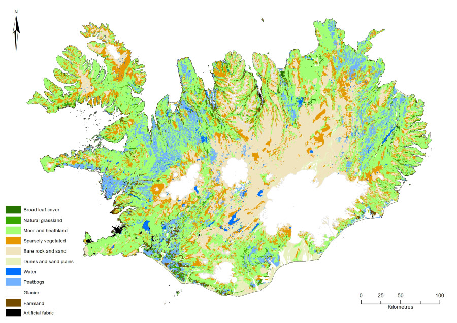
What of grazing areas themselves? Medieval heathlands, and today’s, are often associated with the place-name toponym -heiðir, as well as the more general legal area term -afrettir, which is like ‘common land’; however, they are tied to specific topographies. The topography of Iceland may be divided into three distinct zones: coastal, lowland and highland. Within each of these zones, there are a variety of sub-zones that largely relate to the geological forces that created Iceland’s unique topography, and these, as well as the latitude, have shaped the vegetation-cover type and land-use preferences. The coastal zone was often the most heavily settled, for instance, where there was a fjord, bay or inlet, there was usually a settlement, and this is where all major settlements are located today. The lowlands (from the edge of the coastal zone up to 350 m OD) that lie beyond the coastal fringe are also areas where settlements were established. Here, the settlement type tends to be dispersed farmsteads, rather than village-like centres, and although these exist today, they are a relatively recent phenomenon. Furthermore, perhaps due to settlements’ proximity to grazing areas, but also due to the nutrient-rich soil that formed over centuries of controlled grazing, there is often a combination of agricultural land for growing hay, defined by a boundary that encloses an area around a settlement’s ‘homefield’ or -tun. On some farms, there are also areas of improved expansion into areas outside the -tun that, in general, emerged with the increasingly mechanised agriculture during the 20th century. Freshwater wetlands also formed in some lowland areas, whose peat was used as a fuel source. Saltwater wetlands, less productive except for their ‘wild’ resources, have formed in areas close to the coastal estuaries, but some of these, especially in the south of Iceland, were extensively drained and used for hay production and grazing some animals in the 20th century. Any earlier systems of use have been decimated, though they are sometimes recorded in farm documents. In some areas of the lowland zone, there are low-lying grazing areas that are within and adjacent to the main agricultural areas, and these played a special role in medieval grazing practices, as I will soon discuss. The third zone, the highlands, although mostly uninhabited, is criss-crossed with trackways, camping spots, and safety shelters or sæluhús. However, these have tended to remain zones of minimal human activity, in the past and today. Although there was coastal marsh and edge grazing (usually on the seaweed), the low-lying and highland grazing areas are also where the heathlands are located. As I will go on to discuss, in the past these were also the spaces where intensive land-management systems were established to regulate land-use. These areas were also the places where animals grazed – sometimes with or without human attendance – during the summer months. However, grazing areas in the highlands, saw seasonal movement into them at the beginning of summer, and then the gathering of animals – mainly sheep, but also horses in some regions of Iceland – at the end of the summer. These practices of unmanaged and untethered grazing were particularly important to the history of Icelandic heathlands.

A map showing coastal, lowland and highland (vegetated and unvegetated) zones.
Discussion of heathlands with regard to grazing will inevitably bring other activities into the discussion. And although today’s grazing is principally associated with the highland grazing land, there is also an important connection to lower-lying grazing areas within, or adjacent to, the main settlement areas of the past. Before addressing the historical grazing practices – which took several different forms – I will discuss the vegetation of the grazing areas.
One of the unique qualities of grazing areas or pasture ranges is their variety of vegetation. Depending on geographic location, elevation and latitude, within the grazing areas there are mosses, lichens, low shrubs (including heather and dwarf birch) and grasses. However, the character of the vegetation of many heathlands that were historically used for grazing has been subject to change, especially in areas sensitive to the effects of stresses caused by initial clearance, overgrazing and environmental changes in the past, or the effects of climate change (principally temperature changes and solar radiation). Palaeoecologist Elín Gunnlaugsdóttir says:
(…) heathlands are widespread in Iceland. The dwarf shrub heaths and the open sward heaths are to be found both in the lowland and in the highland. The mossy heaths, e.g., the Racomitrium heaths, generally belong to the highland vegetation but are also found in the lowlands of SE, S, SW, W and NE Iceland. The grassy heathland is most common in the lowland of S Iceland (cf. Steindórsson 1964).
( 7 )
Gunnlaugsdóttir 1985, 5
Access to the heathland resources has changed over time, and to some extent one may see an alignment between the heathlands as they evolved, and the grazing systems of lowland communities.

Icelandic land use (a –data: Land og skógur, LMÍ), and a close-up of a heath showing its rich vegetation (b).
To this end, grazing practices are part of the entangled human–animal–environment histories of heathlands and grazing in Iceland, and of three different practices: 1) a land-division system that divided the land into plots that were located on low-lying heathland; 2) shieling or seasonal settlement related to grazing on a farm’s property, sometimes on low-lying heathland, but always close to the farm; and 3) a community-based grazing practice on highland heath. These practices intermeshed spatially and temporally; however, how these worked together is debated.
( 8 )
See Aldred 2008
What we can say is that the Icelandic farming community was primarily a dispersed territorial system based on a ‘home range’ for summer grazing of sheep and cattle, with haymaking around the farm for winter fodder.
( 9 )
E.g. Vésteinsson 1998, 2000, 2006; Einarsson & Aldred 2011
During the medieval period, many farms also had outlying, seasonally-used settlements or -sel, which are also known as shielings. These were used for both summer and winter grazing. Sometimes, they acted as staging posts in highland areas, and some of the rights of access were held in common, whereas others were more exclusive; what this meant is that rights of access occurred at different times of the year, and that this was done with a small, hence exclusive, number of farms. The intersections between these various operating systems are something that I will explore in the subsequent discussion.
Historical Grazing:
The Control and Regulation of Spaces
To situate Iceland’s historical grazing practices, we need to understand the settlement process and its role in regulating spaces that animals occupied during their summer grazing period.
( 10 )
See also Evans Tang 2022
Winter grazing did occur, but this was often dependent on having access to areas cleared of snow – usually because they were cleared by prevailing winds. Farm access to grazing areas during the summer months was a principal requirement since the onset of settlement, and probably adopted a Norwegian and a British settlement model.
( 11 )
Jesch 2015
The settlement of Iceland was part of the westward expansion of the Viking people: first Britain, then the Faroes and then Iceland, followed by Greenland and probably Newfoundland in the 10th century. Settlement in Iceland started shortly after 871 ±2 CE, which is the scientific date of the landnám tephra.
( 12 )
Vésteinsson et al. 2002; McGovern et al. 2007; Jesch 2015
This is also supported by the archaeological evidence so far: the majority of dating from secure contexts is not earlier than this date. Thus, as a general trend, the landnám tephra is intimately associated with settlement through colonisation. There are a number of colonisation theories, such as 1) pioneer settlements that divided the land for the subsequent settlers; 2) pioneer settlements comprising several households, which then dispersed and formed individual farmsteads; 3) settlement of the best or primary land, followed by lesser land associated with secondary settlement.
( 13 )
Vésteinsson 1998, 2012; Vésteinsson et al. 2002
However, they remain unsubstantiated.
( 14 )
Evans Tang 2022
That said, by most accounts, colonisation or settlement was a relatively rapid process that occurred over perhaps just a few generations of settlers, supported by extensive excavation and tephrochronology in at least one area, around Lake Myvatn in north-eastern Iceland.
( 15 )
McGovern et al. 2007; Vésteinsson & McGovern 2012, 215
How the colonisation process worked more specifically is not known, but the long-held European prehistoric inferential models suggest that it started at coastal and river valleys, adjacent to wetlands, after which there was expansion into woodland areas that were subsequentially cleared.
( 16 )
Evans Tang 2022, 28
Beyond the coastal and river valley areas, what the initial settlers to Iceland encountered in the 9th and 10th centuries was land that was covered by arctic birch (Betula pubescens), scrubland and vegetation on the moors and some areas of lava, and some of the uninhabited parts, which were mostly heath-like, were dominated by low shrubs such as dwarf birch and Crowberry.
( 17 )
Einarsson & Aldred 2011
With lowland and inland communities, at some distance from the sea, mixed agriculture was dominant: cropping and hay growing, with animals such as pigs, cattle, sheep and horses, though after the initial settlement period, there was a relatively rapid transition to just hay growing, and with animal husbandry, mainly cattle, sheep, and horses.
The historical evidence of settlement is quite compelling, and explains in more general terms how this process occurred. For example, the Landnámabók (the ‘Book of Settlement’) says that a limited number of settlers initially settled Iceland, dividing the habitable and uninhabitable coastal and lowland areas among them. The primary location that this group selected for settlement comprised the best farmland, and these places subsequently became the economic, political and social centres. The rest of the land was subsequently settled according to various tiers of available land. Although this is an important historical framework for grazing practices, it does not require any more discussion, insofar as these initial, primary settlements and families were also the regional actors with the most influence. From a historical perspective, these groups appear to have dictated the terms of grazing, or at the very least, have had some element of control over the grazing system and how it was operationalised from the settlement period until relatively recently, in the late-19th century. However, when we investigate the archaeology of the first large-scale grazing practices connected with the land-division system that divided the grazing areas into low-lying heathland enclosures, there does not appear to be a direct correlation between these influential centres and grazing. It appears to be much more nuanced than this.
Grazing Within Land-Dividing Enclosures
The best example of large-scale land-division in the Icelandic landscape is found in the north-east where there is an exceptionally well-preserved Viking Age settlement: these are principally in the form of turf with some stone boundaries (Figure 4). An investigation of a well-preserved area of the boundary system was part of a major research project that ran from 2004 to 2006.
( 18 )
Einarsson et al. 2002; Aldred et al. 2004, 2005, 2007; Einarsson & Aldred 2011; Einarsson 2015, 2019
Over 600 km of the boundary systems have been mapped during this period and since, with the boundaries often stretched across the low-lying heathland, and dividing territory of the settlement and farm land into distinctive parts or enclosures. And in this instance, low-lying heathland was usually within farm property, rather than located in commonly held land (Figure 5). These boundaries established various parcels of the land as kinds of enclosures, for want of a better term, which were used to contain grazing animals, such as horses, sheep and cattle.

A boundary being excavated.
Along with the mapping of the boundaries in north-eastern Iceland, small trench excavations of various parts of the boundary systems were carried out. The excavation trenches (26 in total) were used to record, characterise and date the boundaries using tephrochronology (the dating of volcanic ash). And although tephra preservation varied, where the boundaries were excavated, they tended to date from their first construction, usually in 9th to 10th centuries (above the landnám settlement tephra) to their abandonment or unmaintained features by the 12th to 13th centuries (above Hekla 1104 tephra). What this suggests is that the boundary system in north-eastern Iceland was probably part of an early land-management system, used during or just after the main colonisation period, and subsequently fell out of use relatively quickly, after a couple of hundred years. Similar boundary systems have been identified in other parts of Iceland, such as Svarfaðardalur and Hörgardalur in Eyjafjarðarsýsla. There may be similar land-division boundaries and enclosures in other parts of Iceland, for example, in the south, but systematic research has not yet been carried out in these areas. I discuss the way the grazing regimes [may have] worked in the north-east after I introduce the second grazing system.

A map showing the distribution of land dividing boundaries across north-eastern Iceland.
Grazing Within a Seasonal Settlement or Shieling System
The farm–settlement–grazing relationship with the land also developed in ways that may have emerged from the more regulated spaces that the boundary system created. This may have been due to the need for a much more specific type of activity, rather than with general grazing, and reflected the need for a much more controlled space/place to operate in. And it may have been in this framework that shielings or -sel, emerged as controlled spaces in which specific activities such as milking, separating animals, or extra hay production occurred. The shieling system may have been introduced to Iceland as the boundary system was during the 9th to 10th centuries, as a component of the farming practices that came with the first settlers, though how widespread it was at this early date is unknown. However, it was a system that, in northern Iceland – in the area of Svarfaðardalur and Hörgárdalur in Eyjafjarðarsýsla – seems to have begun after the boundary system fell into disuse, after 1300 CE (according to current knowledge; subject to change). As I suggested, the original settlers’ cultural package included a shieling system (-sel, seater or seter) that may be traced back to the Iron Age in Norway.
( 19 )
Magnus 1986; Øye 2003; Skrede 2005
Nevertheless, the shieling system may have been influenced by the inhabitants of the northern isles of Scotland and Ireland, where a similar system was in use (airge).
( 20 )
Lucas 1989; Costello 2021; Foster 2021


A shieling’s rangeland in Svarfaðardalur (Sakkasel (left) and Bægisársel – EY-264:010).
Irrespective of the origins of -sel in Iceland, they were inextricably linked to land that was part of the farm property; this could be a detached portion, or on the farmland in question. But the question that I will explore later in this paper is how the regulated spaces of the boundary systems aligned with the more specifically-controlled spaces of the shieling systems. The main purpose of shielings seems to have been to enhance a farm’s economic activity. In saga and early literature (12th to 15th century), shielings are sometimes referred to as summer houses (sumarhús), and the farm as the winter house (vetrarhús). The use of seasonal settlements also indicates how these places were perceived, as well as linking their use and function to a farm’s economic system: as a seasonal spaces for a range of activities, rather than just places to live.
( 21 )
ÍF V, 97; Hreiðarsdóttir et al. 2023
However, one excavated example in Iceland, Pálstóftir, a multi-roomed 10th-century structure, was used as a hunting lodge, and given this, was part of a ‘decentralised’ farm economy.
( 22 )
Lucas 2008
Pálstóftir is unlikely to be an exception, and there are probably other sites like it, but it suggests that as the concept of land changed (in terms of the legal requirements, farms as property and land use), so too did the shieling. It is possible that initially shielings were used during the settlement of Iceland as a way to assert property, as a part of the land taking practice of primary and secondary settlements. Shielings then evolved as an economic response to farm activity and in the creation of mini-farms; seasonally used settlements for specialist craft activities including hunting. Eventually, shielings became a place for retaining specific types of animals, such as milking cows, away from the herd, over the summer.


Shieling (Sakkasel) under excavation.
Part of the problem with the archaeology of shielings is that, although we have a reliable understanding of how the shielings functioned from the late medieval period onwards, we do not really know how they were integrated into either the broader or narrower economic system of the farm, apart from in the case of the one fully excavated example, Pálstóftir.
( 23 )
Lucas 2008
This is partly because shielings appear to have broad and varied uses through time, and furthermore, very few have been investigated as comprehensively as Pálstóftir.
( 24 )
For smaller-scale investigations, see Sveinbjarnardóttir 1991; Hreiðarsdóttir et al. 2023, 2024
What may be clear is that some early shielings were reoccupied in later times, and became more permanent settlements; others were integrated into the farm’s economic system that blended the farm–shieling into a seasonal transhumant system, whereas still others, such as Pálstóftir, were abandoned as the economic systems changed. Thus, although later activities at shielings were connected to moving animals from the farm to preserve the homefields for winter fodder, other sites, such as Pálstóftir, suggest that other kinds of activities, including hunting, also occurred there.
A traditional view of a shieling, perhaps influenced by post-18th century histories, is that shielings were involved with smaller-scale movements between a home farm and the shieling, sometimes on a daily basis, at other times, seasonally. This type of transhumant movement pattern is called ‘lesser transhumance’,
( 25 )
Fox 2012
and is usually associated with milking cows and sheep that could be returned daily to their home farm. But clearly, as with Pálstóftir, shieling sites could also have had other uses, such as hunting lodges, and other examples show that they were used for additional hay production, charcoal burning and as a staging posts for general outfield maintenance on farm property, depending on the location of the shieling.
( 26 )
Borchgrevink 1977
Shielings were also social spaces, often at the limits of the farm property where people gathered with others, and their animals.
( 27 )
Kupiec 2016; Costello 2018
It is not fully known when -sel became widespread throughout Iceland or when they began to fall out of use. Several regional projects have been conducted,
( 28 )
Sveinbjarnardóttir 1991
though their conclusions have been unclear, owing to the range, diversity and functions of shielings as transhumant summer sites. However, a research project that aims to address this question is currently being carried out in two areas of Iceland: the north-east and south-west.
( 29 )
The Rise and Fall of Transhumance in Iceland 800–1800 – Rannís grant nr. 228883-051; Hreiðarsdóttir et al. 2023, 2024
Extensive Grazing and the Communal System of the Roundup (Göngur og Réttir)
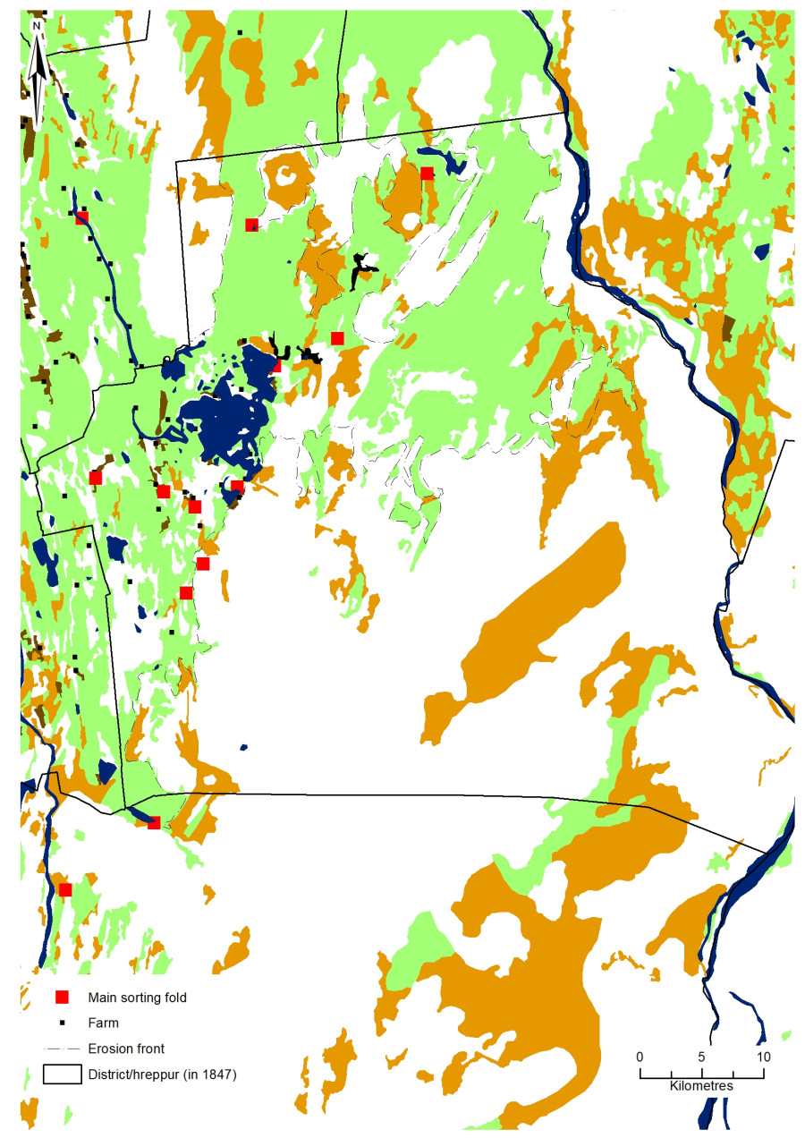
A third grazing system operated alongside the regulated and controlled grazing systems associated with boundaries and -sel. The precise chronology of this extensive and communal grazing system is under-researched, though in the main it is a much later, post-18th century practice, with hints of a much earlier communal grazing system. The system operated mostly in connection with the summer grazing of sheep (also horses, in some regions of Iceland) in the highland heath beyond the limits of the farmland and the settlement zone. However, although grazing took place on communal land that belonged to a community – beyond the so-called settlement zone – initially it may not have been a completely communal system, as it was from the 18th century onwards. Instead, and perhaps more common in earlier periods, it may have been an exclusive grazing system whereby just a few farms had rights to graze their animals, and others in the community did not, and had to make do with areas on their own farmland, or poorer-quality land. For example, a small group of medieval farms in Skútustaðahreppur and Helgastaðarhreppur (Reykjahlíð, Skútustaðir, Arnavatn, Grænavatn, Grimsstaðir and Þverá, Einarsstaðir)
( 30 )
Vésteinsson 2004, 8
had exclusive rights to graze sheep in the southern pastures of the district – the best grazing area at the time (Figure 8).

Map showing the locations of Einarsstaðir, Reykjahlíð, Skútustaðir, Arnavatn, Þverá, Grænavatn and Grimsstaðir, and their grazing area (data: Land og skógur, LMÍ).
Precisely how this earlier grazing system worked, with its areas reserved for just a few of a community’s farms, is not known,
( 31 )
See Vésteinsson 2004
but it probably was a precursor to the post-18th-century communal grazing system, and used similar devices and operations such as animal markings (on the ears) and animal folds to gather, sort and divide animals into their respective farm holdings. Besides the use of a system that allowed just a few farms to use communal pastures, we also know that this took place at least during the 13th century, as it is discussed in the ´grey goose´ legal book, Grágás.
( 32 )
Dennis et al. 2006
This was a grazing system that may have been integral to the formation of communities, and possibly to the establishment of the legal community district or -hreppur system that emerged sometime between the 11th and 13th centuries. For example, in Grágás there is reference to gathering sheep and to the process of deciding on a new ear-mark, which implies that this system operated at the time of Grágás’s publication; this also implies that it was not so different from the later, post-18th-century summer grazing system. In this respect, we can make some inferences about earlier practices, in light of the post-18th century practice. For instance, grazing sheep probably began with the sheep (or other animals) being driven into the highland grazing areas at the beginning of summer, say in June. They were then left to graze unattended in the highland heath until September, when they were gathered and driven as a herd into the sorting fold, and divided into their respective farm holdings. Thus, as units of a communal grazing system, each sheep was marked with an owner’s mark – usually on the ear, with a distinct shape – allowing them to be sorted into farm holdings (see Figure 9).

Earmark system.
The recent history of gathering and sorting sheep in Iceland has been transcribed into four volumes: Göngur og réttir,
( 33 )
Sigurjónsson 1987
where the concerns and history of this practice, from the 19th century onwards, have been recorded. And, these later, local histories showcase how people, animals and grazing areas coincided.
Human–Animal Responses to Change
What I will discuss now are some of the various ways that the three previously-discussed grazing systems intersected, from the 9th to 19th centuries, and the role and importance of the heathland – the best grazing areas available for all three systems. All three systems relied on access to good grazing, as did the systems of control that were used to manage them, including protecting them from over-grazing. In this discussion, I will provide an interpretative commentary on the possible associations between environmental changes and the subsequent human responses to which the histories of these grazing systems were connected. This will inevitably touch on the various kinds of natural and socio-ecological forces that have affected heathland ecosystems over time. And therefore, this will examine how humans have responded to change – whether natural or cultural shifts – that required some resilience on the part of farmers and their respective communities.
The immediate question that needs to be addressed is the dating of the three systems. However, this is an unreliable approach as there are simply not enough data and dates on which to base more than general comments. What is more, this may be considered from a regional perspective only in areas where there has been enough research. Thus, this commentary applies only to north-eastern Iceland, where all three systems appear: occasionally simultaneously, at other times, not (Figure 10). Furthermore, the archaeological evidence suggests that local conditions heavily influenced the way grazing systems developed, and even if a national picture could be presented, it would still be necessary to unpick and present the local perspectives. Even Iceland’s north-east requires further subdivision, as from one district to the next quite different systems may have been in operation. To move forward with this, what is required is to establish some initial premises concerning each of the three grazing systems, and assess these through the framework of several broad chronological ranges: 9th to 13th centuries; 13th to 18th centuries; the 18th century onwards.

The area of north-eastern Iceland studied here, with all three grazing systems marked as represented by 1) boundaries, 2) shielings and 3) sorting folds.
During the first period, from the 9th to 13th centuries, the boundary system was the dominant system. This was a regulated system that aligned well with some of the principles that underpinned the dispersed character of the community as farm units during this time. It is probable that the more exclusive system of grazing (prior to the post-18th century system) and the shieling system were also in operation. This also includes a boundary system, with a few examples that are starting to emerge from new research on farms and shielings in Svarfaðardalur, Skiðadalur and Þorvaldsdalur, as well as Hrisey in Eyjafjarðarsýsla. And yet in some areas, there may have been just a shieling system in operation, without a boundary system. Unfortunately, we are not yet at a stage where we can interpret Iceland’s entire grazing system history. Instead, for this early period at least, local studies are proving to be illuminating but sometimes contradictory, from region by region. Overall, the best understanding of the early period comes from a combined approach to historical and environmental sources, with archaeological evidence, such as the excavations across boundaries in north-eastern Iceland, at the forefront. There is some limited historical evidence that is not always reliable and mentioning only standardised statements.
( 34 )
E.g. height of the boundaries, and regularity of maintenance in Grágás 2000
The regulated boundary system may have worked hand-in-hand with the shieling system, because in many respects these operated in similar ways. On the one hand, they had specialised functions, such as the separation of particular animals, such as wethers and lambs, or milk cows, from the rest of the herd, and on the other hand, they operated on the farm property, rather than beyond it. In this respect, various topographies and heathland characteristics could be used to suggest various systems that operated in succession, or perhaps as concurrent, parallel systems that contributed to the economic and social functions of the community, in various ways. Overall, the boundary system in north-eastern Iceland was mostly used from the 9th to 13th centuries (Figure 11), although elements of the boundary divisions were occasionally reused and continued after the 13th century, and shielings and a system of exclusive grazing in the highlands were probably used by a few farms.
During the second period, from the 13th century to the 18th century, the regulated boundary system had largely broken down in the north-east. This probably occurred well before the 13th century, though the homefield -tun around the farms continued to be built and maintained with boundaries, enclosing hay fields around the farmstead, keeping animals out during the hay-growing season, and also keeping animals in. So, although there was a need to protect hay production in the homefield, manuring may have taken place at set times of the year, such as at the end of the summer, after the last hay had been cut. Besides the regulated space of the infield/homefield, another regulated space, the shieling system, controlled aspects of the grazing system and of deciding which animals grazed where on a farm. This emerged as a dominant system in this period. The shieling system probably operated alongside an extensive, and perhaps still exclusive, community system of sending animals to the highland grazing areas. However, it provided additional functionality in terms of a much more controlled and managed arrangement for specialised activities. It meant that groups of people and animals could be located away from the farm but close enough to move back and forth to and from the farm, on a daily basis. There may have been a local dimension to this, and topography and access to good grazing were key. In some places, the shielings were probably intentionally situated on heathlands to provide access to good grazing areas, or there may have been a strong requirement to access a constant and reliable water supply. Again, how the exclusive communal system of grazing aligned with the shieling system is uncertain, but this depended on the quantity of animals a farm had. For instance, a shieling system beside a farm’s outfields (i.e. not the infield/homefield area) was likely to cater to sheep, horses and cattle (Figure 11). And again, local conditions perhaps dictated the requirements, and whether they afforded anything beyond the smaller-scale farming interventions.

A representation of the land-division system and how it was used (after Einarsson 2015, fig 11, 2019).
The third period, the post-18th century, is perhaps the one that is best understood from a historical perspective. In some areas of Iceland, the post-18th century grazing system switched from an exclusive and shieling-based system of highland grazing to an entirely communal system. This involved taking the community’s sheep to the highlands for grazing, and strict regulation by the community. As a result of this switch, other structures were developed, such as the sorting fold (see Figure 14), and a community committee that kept track of the numbers of sheep, and the tax presumably paid to use the grazing areas or to pay for driving and gathering sheep into and from highland grazing areas, at the beginning and end of the summer. However, although the human side of the system was highly orchestrated (in terms of the committee, the earmarks, the gathering and division of animals), the animal side of the system was transformational: as the animals moved from the farm to the grazing area, they became free-roaming, whereas when they moved in the other direction, they were confined, or ‘incarcerated’ to use Revel Netz´s language.
( 35 )
Netz 2004; Aldred 2018
In general, there is a clear sense of some general chronologies of when certain kinds of systems operated. to summarise, the regulated enclosure boundaries were in use from the 9th to the 13th century; the shieling system since the 9th century, but predominantly from the 13th/14th century, and highland grazing first as an exclusive system from the 9th century until the 18th century, after which the practice became a community activity. Precisely how these various systems overlapped, especially in the 9th to 13th centuries, still needs to be determined, but this is best considered on a case-by-case basis.
Perhaps the next question to consider is that of the forces that drove change within the various grazing systems, and also initiated the shifts between them. This is apart from the requirements that suited various geographies/topographies, but might have involved economic requirements, and social forces and the desire for sustainable environmental practices to avoid degrading the grazing vegetation, especially when it came to important resources such as heathlands. By examining each of these forces independently of one another, acknowledging the fact that in some cases there were several forces at work, it is possible to draw some initial conclusions. Nonetheless, specific case studies of each of these forces of change will be discussed, before bringing them all together in a final discussion.
The 9th- to 13th-century forces of change were probably prompted by the requirements of local-scale land provision. Here, the topography of the land, with respect to farm location, incentivised the division of good grazing areas, including parts of the lowland heath. For example, the area of low-lying heathland, Fljótsheiði and Hvammsheiði in Helgastaðarhreppur, are criss-crossed with boundaries that once divided the low-lying heath of the farmland into distinct, regulated spaces for grazing (see Figure 12). The impetus for this has been discussed in several different ways, for example, the territorial competition among farms, or meeting the requirements of the regulated legal tradition that outlined the penalties for animals grazing on another’s property.
( 36 )
Einarsson 2015
The division of grazing areas was simply a response to these factors. Interestingly, even when the boundaries are no longer visible as earthworks on the surface (largely due to have been buried by windblown sediment), an erosion scar is present along the original alignment. This gives a good indication of where the boundaries of the boundary system are located, even when it is difficult to see the boundaries in aerial photographs, or in the field.
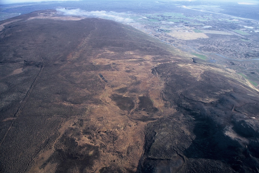
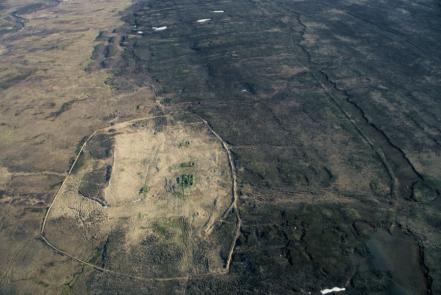
Photographs showing Fljótsheiði and Hvammsheiði in Helgastaðarhreppur and their boundaries (left), and Narfastaðasel with its erosion scar (right).
From the 13th to the 18th century, shieling systems were the dominant grazing practice, either in conjunction with remnants of the pre-13th century boundary system or the exclusive communal grazing system. Clearly, what drove the choice of shielings was a complicated process, but in Iceland’s north-east it was perhaps largely due to the amount of lowland grazing available, along with the demand for specialised activities dictated by the shifting economies of the farm unit. Furthermore, the changes in the governance of Iceland, from independent state to part of the Norwegian commonwealth in the 13th century, probably influenced the way in which land management was carried out. However, the shieling system – which established a controlled space for milking, hay production and other activities – became the dominant grazing system for specific kinds of animals. In Svarfaðardalur, Skiðadalur and Þorvaldsdalur, the shielings lie higher than the home farm, usually in the lowland heath areas (Figure 13). They may also lie at the junction between the farmland and the grazing area, and sometimes on good grazing land on a farm’s land.

Shieling system in Svarfaðardalur.
After the 18th century, the communal system was the dominant grazing system. This was largely driven by foreign demand for wool, as Iceland moved towards becoming a more industrialised nation.
( 37 )
Robertsdóttir 2008
For example, throughout Iceland as a whole, there was a huge increase in the numbers of sheep, from a low of 64,459 in 1785 to a high of 516,853 in 1853.
( 38 )
Jónsson & Magnússon 1997, 279–280, Table 4.13
In one community, Skútustaðahreppur, we see the numbers of sheep rise steadily from 1703, to a five-fold increase by 1910.
( 39 )
Table 1, & see Aldred 2018
And these numbers indicate that from the 18th century onwards there was an intensification of sheep farming. There is also a correlation with the development of structures associated with this practice (Figure 14). As may be seen in Figure 15, several sorting folds were located on the grazing areas beyond the settled zone, and these were probably the earliest sorting folds. As the erosion front moved inland, the sorting fold moved closer and closer to the lowland settlement zone.

Sheep counts derived from documentary sources: 1703 & 1712 farm surveys, and from district’s farm committee’s book – fjallskílabók – for Skútustaðahreppur. * Without lamb numbers.

Surveyed sorting folds using DGPS and aerial photographs. Key – a) Gautlandaréttir; b) Sellandarétt; Strengjarétt; d) Dalsrétt; e) Hliðarétt; f) Réttartorf g) Réttargrund; h) Baldursheimarétt; i) Stöng; j) Péturskirkja.

A photograph of Skútustaðahreppur’s erosion front and a map of sorting fold locations.
An alternative explanation of why changes in the grazing system occurred, and one that may have had a different kind of response during each period, was the effect of environmental change on vegetation growth. This shaped grazing practices and the impact of overgrazing year after year, in an environment that was sensitive to vegetation growth, especially in heathland. For example, in Skútustaðahreppur after the 18th century, the committee that regulated the community-based system was acutely aware of the impact of grazing on certain areas.
( 40 )
See Aldred 2018
In some places, the loss of vegetation was extensive, and with it, the loss of soil, as it was blown away (up to 2 to 3 m in places). And, as already mentioned, as the erosion front moved inland, where the earliest sorting folds in Skútustaðahreppur were located, the later sorting folds moved closer to the settlement zone. In fact, one of the sorting folds, Stenjarétt, which once lay on the heathland, but close to the settlement zone, now sits in a desert several kilometres from the nearest farm (Figure 16). The erosion meant that the heathlands within the grazing areas gradually became increasingly isolated from one another as the erosion front and the area of vegetation and soil loss increased. This also made the grazing areas a resource susceptible to further loss, if left unmanaged. This forced the community to regulate the grazing of sheep in the southern grazing area, Suðurafrétt or ‘southern common land’, and Austurafrétt, ‘eastern common land’.

Stengjarétt
Discussion
Discussions of the relationships among the three grazing systems (regulated space formed by boundaries, the farm’s relationship with a summer shieling-site system, and the communal grazing system) usually occur separately, rather than together as an ecology.
( 41 )
Although see Aldred 2008 for a limited discussion of this
In fact, as the title of this contribution suggests, these ecologies of grazing are interdependent with one another, formed through the entanglements of human and non-human actors. With regard to this, although this is an ambitious paper, I opted to leave open areas for future improvement, but initiated that process by exploring the relationships among the three systems. In general, I have argued for a certain amount of contemporaneity among the three grazing systems, but presented a single dominant form within each period. And I have observed that the system has gradually become more democratic and communal in its operation, perhaps out of necessity, rather than by design. As agriculture in Iceland shifted from a mixed system of arable and animal husbandry to mainly hay production with cattle and sheep, and then principally to sheep, the grazing needs of settlements and their regional and sub-regional communities changed. And although this varied regionally, change in the farming strategy at the community level (valley by valley or district by district) was probably one reason that the grazing system also changed. Several different factors influenced the farming strategy, some of which I have discussed above. Furthermore, although economic arguments usually prevail when explaining the shift from one grazing system to another, other factors were at work, too, such as environmental change and shifting socio-political factors.

Chart showing how each grazing system temporally aligned.
The research into the interplay among these three systems continues, but until a clear picture of regional trends, and the various places and structures involved in each of the systems is consistently dated, it is difficult to discuss with great confidence why these various systems operated with less and greater intensity at some locations, why different areas exhibit different trends, what the relationships were among the three systems over time, and what the drivers of change were and their effects on communities. However, what appears to be central to all these questions is the heathland, the land on which Iceland’s grazing system has centred. For instance, the low-lying heathlands have tended to contain sites connected with boundaries, shielings and sorting folds, first lying in-between the settlement zone and the heathland areas, and then moving into the settlement zone, as the heathland vegetation started to be degraded and the erosion front moved. The shieling system was also dependent on well-maintained pastures, giving it time to recover from use, but also managing the influx of animals in a way that allowed the vegetation to recover season by season. The latter is particularly true of locations that were less accessible, making it hard to provide additional cut hay for feeding animals at the shieling. And what is more, the boundary system was an inherently controlled system, designed with this form of regulation in mind, but which was ultimately unsuccessful. The change from one system to another also reflects the kinds of spatial control and regulation required to ensure sustainable grazing practices, and this would have prompted more competition, perhaps between various land holders, and therefore requiring the adoption of a fairer system. The boundary system was a materialised rather than a perceived kind of control, embedded in the physical boundaries that divided the lowland grazing areas into distinct enclosures, backed by a legal framework or laws. The post-18th century grazing system – both its earlier exclusive and later communal version – fluctuated between a controlled system of set times and actions and an uncontrolled one, such as when sheep were released into the grazing areas untethered. Also, there was a district organisational committee that pulled the strings from afar, so to speak, and determined which areas could be grazed (this is something that happened in Skútustaðahreppur). The latter had a highly controlling and orchestrated system of gathering and sorting, which manifested itself materially, but this was not about the controlled use of grazing areas when animals were grazing. Much more research is required, to consider these three systems together, but for now, I have offered some initial observations.
*
All three grazing systems – the boundary enclosures, the shieling and extensive/communal – were concerned with certain kinds of movement to which heathland was integral, and we may view the archaeology of heathland and its operation as a mode of mobilisation. In this sense, movement is not only about its control within a grazing space: control in the sense of restricting access to and from bounded spaces, or separating animals into groups and moving them, or producing animal produced secondary products such as milk and wool, with movements to and from the shieling, or driving animals into the highland grazing areas and back again. It is also about encouraging certain kinds of movement within the spaces connected to each system. For instance, the circulation of movement of animals within the boundary enclosures, perhaps enriching the soil and sustaining the vegetation’s growth for the following year (like a kind of rotation); the movement of animals from one part of the farm to another for specific activities such as milking and also protecting hay in the homefield -tun; and the unconfined movement of animals, and the forms of multispecies mobilities connected with driving and dispersing, and gathering and rounding-up at each end of the summer, into highland grazing areas.
When grazing areas such as heathlands are viewed in terms of spaces and movements, with an understanding of their temporal framework – even in a general way – as a complete system, it starts to come alive as a practice; one in which the maintenance and sustainability of the heathland were critical to the perpetuation of the system in question. The highly controlled and regulated systems of boundaries and shielings, built on a farm-by-farm basis, were, in many ways, the complete opposite of the communal grazing system. And perhaps the latter best suited the Icelandic environment and the cultural requirements that emerged from social and economic necessities. The communal grazing system is a practice that continues today throughout the whole of Iceland, one that was much more successful than the other two, which stopped functioning (in general): the boundary enclosures in the 11th or 12th century, and the shieling system in the 18th century. The extent to which the grazing areas, such as the low-lying heathlands, in particular, were formed through an initial, destructive vegetation clearance, are now subject to secondary destruction from overgrazing and/or from the effects of climate change, which is a question to be acted on, rather than just observed.
My thanks to Mark Haughton, who suggested that I write a piece for this publication after seeing some of the recent research on shielings I have been involved with colleagues from Institute of Archaeology, Iceland and University of Iceland TRANSICE Rannís-funded project. Also, my thanks go to Mette Løvschal for giving insights about her research on heathlands at a recent conference that I organised in Cambridge. Furthermore, I thank Karen Grønneberg and several anonymous reviewers, who only improved this paper. The McDonald Institute for Archaeological Research, University of Cambridge awarded a grant that also supported aspects of this article. And, finally, I thank my friends and colleagues at the Institute of Archaeology, Iceland, who have been with me on many journeys across Iceland in spirit, if not always in person.
Aldred, O. (2008). Unfamiliar landscapes: infields, outfields, boundaries and landscapes in Iceland. In A. Chadwick (Ed.), Recent approaches to the archaeology of land allotment (pp. 299-321). Oxford: Archaeopress. (BAR International series 1875).
- E.g. Aðalsteinsson 1981, 1991; Aldred 2018; see also a study of Norway – Armstrong Oma 2018 ↑